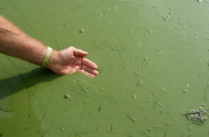
According to the Western Lake Erie Basin Initiative – Fiscal Years 2016-2018 by the USDA Natural Resources Conservation Service, ecological shifts have occurred in the Western Lake Erie Basin (WLEB) and Lake Erie where algal blooms, reminiscent of the 1960s when the Lake Erie water quality had degraded so severely that many referred to the lake as being “dead,” are once again occurring as a result of increased nutrient levels, phosphorous in particular. Algal blooms can severely reduce or eliminate oxygen in the water, leading to illnesses and death in large numbers of fish. Also, some algal blooms produce elevated toxins and bacterial growth that can make people sick if they come into contact with or drink polluted water or consume tainted fish or shellfish. To monitor harmful algal blooms, the National Centers for Coastal Ocean Science releases weekly forecasts identifying which blooms are potentially harmful, where they are, how big they are, and where they’re likely headed. Also, Lake Erie Algae provides in-depth information on the issue.
A significant portion of the phosphorous contributing to the blooms originates from surface and subsurface losses of commercial and organic fertilizer applied to agricultural land. Runoff from farm fields due to rainfall or snowmelt also carries soil particles, known as sediment, with it that enter local waterways and eventually end up in Lake Erie. These soil particles become suspended resulting in murky water that can affect the health of numerous aquatic species.
Conservation practices applied as a system will reduce both nutrient and sediment losses. These include planting cover crops, following nutrient management protocols, installing conservation buffers and two-stage ditches, and utilizing drainage water management systems.
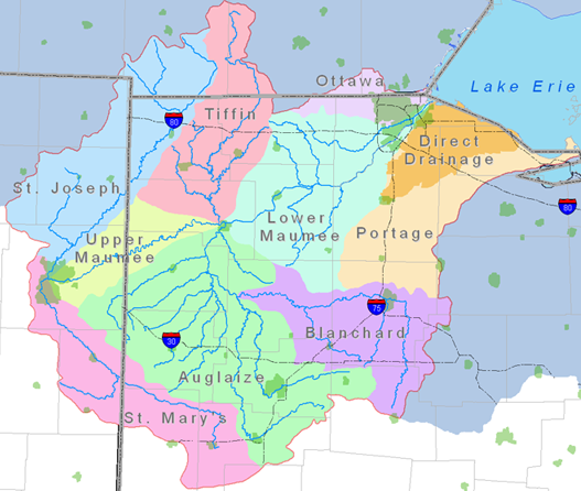
The WLEB watershed is the most heavily agricultural Great Lakes watershed, consisting mostly of corn, soybean and wheat production. The St. Joseph River, St. Marys River, and Upper Maumee River watersheds are watersheds within the WLEB that are a primary focus of the Tri-State Watershed Alliance:
- St. Joseph River watershed
Lake Erie algae bloom, 2011 (Credit: Jeff Reutter/Ohio Sea Grant) - located in northeast Indiana, northwest Ohio,
and south central Michigan - encompasses 699,867 acres
- approximately 64% used for agriculture
- located in northeast Indiana, northwest Ohio,
- St. Marys River watershed
- located in northeastern Indiana and northwestern Ohio
- encompasses 507,752 acres
- 84% used for agriculture
- Upper Maumee watershed
- located in northeastern Indiana and northwestern Ohio
- encompasses 247,919 acres
- 85% used for agriculture
To learn more about the WLEB, view “A Watershed Mentality.”